


The Continent Lemuria of Ancient Tamil Nadu
The conditions were favorable for the growth of living organisms only at Cape Comorin which was submerged after the Tsunami. Because of this evolution of man would have taken place then. The language spoken by those people was the basic of Tamil Language. The researchers believed that those were the ancient Tamilians. People who lived on the southern part of the land mass are considered as the ancestors of the people of Cape Comorin. There was a big land mass connecting Africa and Australia, which was called Lemuria after the name of the monkey Lemur. It was believed that human beings evolved from the Lemurs. The language of the people was ancient Tamil. The land where their descendants lived was called Tamil Nadu.
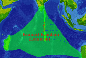
There are scattered references in Sangam literature, such as Kalittokai 104, to how the sea took the land of the Pandiyan kings, upon which they conquered new lands to replace those they had lost.[1] There are also references to the rivers Pahruli and Kumari, that are said to have flowed in a now-submerged land.[2] The Silappadhikaram, one of the Five Great Epics of Tamil Literature written in first few centuries of CE, states that the "cruel sea" took the Pandiyan land that lay between the rivers Pahruli and the mountainous banks of the Kumari, to replace which the Pandiyan king conquered lands belonging to the Chola and Chera kings (Maturaikkandam, verses 17-22). Adiyarkkunallar, a 12th century commentator on the epic, explains this reference by saying that there was once a land to the south of the present-day Kanyakumari, which stretched for 700 kavatam from the Pahruli river in the north to the Kumari river in the south. As the modern equivalent of a kavatam is unknown, estimates of the size of the lost land vary from 1,400 miles (2,300 km) to 7,000 miles (11,000 km) in length, to others suggesting a total area of 6-7,000 square miles, or smaller still an area of just a few villages.[3]
This land was divided into 49 nadu, or territories, which he names as seven coconut territories (elutenga natu), seven Madurai territories (elumaturai natu), seven old sandy territories (elumunpalai natu), seven new sandy territories (elupinpalai natu), seven mountain territories (elukunra natu), seven eastern coastal territories (elukunakarai natu) and seven dwarf-palm territories (elukurumpanai natu). All these lands, he says, together with the many-mountained land that began with KumariKollam, with forests and habitations, were submerged by the sea.[2] Two of these Nadus or territories were supposedly parts of present-day Kollam and Kanyakumari districts.
None of these texts name the land "Kumari Kandam" or "Kumarinadu", as is common today. The only similar pre-modern reference is to a "Kumari Kandam" (written குமரிகண்டம், rather than குமரிக்கண்டம் as the land is called in modern Tamil), which is named in the medieval Tamil text Kantapuranam either as being one of the nine continents,[4] or one of the nine divisions of India and the only region not to be inhabited by barbarians.[5] 19th and 20th century Tamil revivalist movements, however, came to apply the name to the territories described in Adiyarkkunallar's commentary to the Silappadhikaram.[6] They also associated this territory with the references in the Tamil Sangams, and said that the fabled cities of southern Madurai and Kapatapuram where the first two Sangams were said to be held were located on Kumari Kandam.
No comments:
Post a Comment